Get update alerts
Locations
- .All Trips
- Art
- Car Culture
- Central America/Caribbean
- Food
- Food Tour
- Pic of the Week
- Sl;ovenia
.All Trips / Argentina / Chile / Food / South America
 Feasting at Sea")
Exploring the Fjords of Patagonia: 8) Feasting at Sea
My final post for this adventure into the Patagonian fjords of Chile focuses on the very wonderful food we were served aboard the Australis. We received three meals a day in the ship’s dining room mostly (as I recall) buffet style, including hearty breakfasts with a large choice of items, a tasty lunch, but no question the highlight of our culinary day was dinner. We had four dinners aboard the Australis and I found each of them photogenic enough to be “documented”. I never planned on making a blog of what I ate, so I didn’t photograph everything — just those items that looked wonderful (and were!)
Besides the very tasty meals, the service of our crew throughout the ship was …
Tagged Appetizer, Australis, dessert, Entrée, fjordlands
.All Trips / Chile / South America
 Wulaia Bay")
The famous British exploration vessel, HMS Beagle, visited the area twice. The first time was during her 1826 – 1830 voyage wherein Captain Fitzroy charted many of the channels in the Patagonian fjords, making for safer sailing of the region. The return journey lasted from 1831 …
Exploring the Fjords of Patagonia: 7) Wulaia Bay
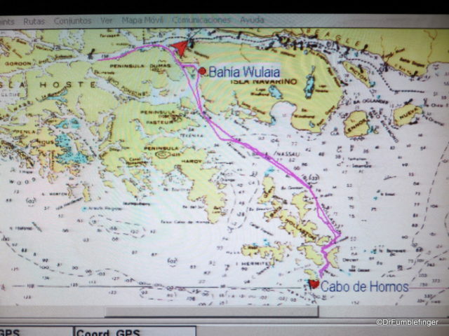
Our final stop before the Australis headed to port in Ushuaia was at historic Wulaia Bay, a pretty spot visited by many navigators over the centuries.
The area around Wulaia Bay has long been settled by man, with archaeological studies showing evidence of human habitation for more than 10,000 years, these being the nomadic Yahgan aboriginal people. The Yaghan population was strong 150 years ago but today has been largely decimated; less than 2000 individuals remain.
Journey to Wulaia Bay
The famous British exploration vessel, HMS Beagle, visited the area twice. The first time was during her 1826 – 1830 voyage wherein Captain Fitzroy charted many of the channels in the Patagonian fjords, making for safer sailing of the region. The return journey lasted from 1831 …
Tagged Australis, Beagle, fjordlands, Patagonia, Yaghan
.All Trips / Chile / South America
 A Storm at Cape Horn")
It would have been nice to walk on this remote island, the most southern point of South America. It was discovered by the Dutch in 1616 and is known as the “End of the Earth”. Cape Horn has a sheer 425-meter (1,394-foot) high rocky promontory which overlooks …
Exploring the Fjords of Patagonia: 6) A Storm at Cape Horn
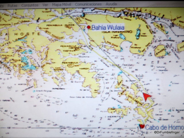
We headed south across Nassau Bay on the morning of our last full day aboard the Australis. Our hope was to be able to go ashore at Cape Horn (Cabo de Hornos), the most southerly island in the Tierra del Fuego archipelago — weather and conditions allowing. When I enquired about what our odds of going ashore were the night before, I was told 50-50. I think, in retrospect, that was an overly optimistic prediction.
Route Map, Cape Horn
It would have been nice to walk on this remote island, the most southern point of South America. It was discovered by the Dutch in 1616 and is known as the “End of the Earth”. Cape Horn has a sheer 425-meter (1,394-foot) high rocky promontory which overlooks …
.All Trips / Chile / South America
 Glacier Alley")
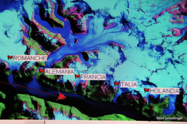
Situated along the Beagle Channel, Glacier Alley is a string of massive and picturesque glaciers that extend to the sea from the massive Darwin Ice Field (which covers 2500 km2) on Isla Grande, the largest island in Tierra del Fuego. These glaciers are named after several European countries — Holland, Italy, Germany, Spain and France (in Spanish — Holanda, Italia, Alemania, Espana and Francia). If it seems a little odd that …
Exploring the Fjords of Patagonia: 5) Glacier Alley
After an interesting morning exploring Pia Glacier and its surroundings, we returned to the Australis as she continued her journey. Our next attraction didn’t require leaving the Australis and could actually be enjoyed from the deck of our ship. We were to navigate through what’s commonly called “Glacier Alley”.
Map of our route through Glacier Alley
Situated along the Beagle Channel, Glacier Alley is a string of massive and picturesque glaciers that extend to the sea from the massive Darwin Ice Field (which covers 2500 km2) on Isla Grande, the largest island in Tierra del Fuego. These glaciers are named after several European countries — Holland, Italy, Germany, Spain and France (in Spanish — Holanda, Italia, Alemania, Espana and Francia). If it seems a little odd that …
Tagged Australis, Beagle Channel, Glacier Alley, Glaciers, Patagonia
.All Trips / Chile / South America
 Pia Glacier")
Exploring the Fjords of Patagonia: 4) Pia Glacier
Having finished a hike in Tierra del Fuego and studied birds up close on Tucker’s Islets, we completed a memorable day with an evening of fine food, good companionship and restful sleep. During the night our ship re-positioned itself and the next morning’s excursion was a visit to Pia Glacier.
Pia Glacier is in the north-west arm of the Beagle Channel and lies on the Darwin Range. It’s an advancing glacier, meaning …
Tagged fjordlands, glacier, Patagonia, Pia Glacier
.All Trips / Chile / South America
 Bird-watching at Tucker’s Islet")
Exploring the Fjords of Patagonia: 3) Bird-watching at Tucker’s Islet
After our morning hike in Tierra del Fuego we returned to the Australis for lunch and some rest, during which time our ship re-positioned itself in Ainsworth Bay. Our afternoon excursion was to be entirely on a Zodiac. This is obviously a slower process than zipping us onshore for the morning’s hike as the supply of Zodiacs was limited.
The Zodiacs took us to a small cluster of islands known as Tucker’s Islets. These lie within the Strait of Magellan and are rich in bird life (note: Magellan was the Portuguese explorer who visited this region 500 years ago). We would slowly circle these islands in the Zodiac to observe the different types of birds, slowing to a stop when possible, …
.All Trips / Chile / South America
 A Hike in Tierra del Fuego")
Exploring the Fjords of Patagonia: 2) A Hike in Tierra del Fuego
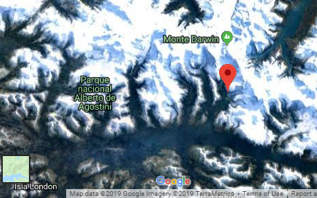
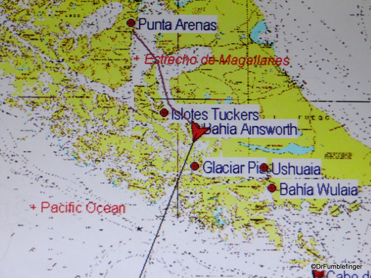
After a good dinner, an evening of pleasant conversation with our fellow cruisers and a good night’s sleep aboard the Australis, we found ourselves in Ainsworth Bay, in the Tierra del Fuego region of Chile. The area is part of the protected lands of Alberto de Agostini National Park. Ainsworth Bay is a fjord fed by the meltwater of the nearby Marinelli Glacier, itself part of the larger Darwin Ice Field.
Our route to Ainsworth Bay
We boarded the zodiacs and were zipped to shore, where in small groups of about 10-12 we were lead by a guide through a subpolar Patagonian coastal rainforest.
The weather was highly changeable. When we landed it was gently drizzling, but after a while the rain broke and soon the sun poked …
“Pic of the Week”, September 7, 2018: Reminders of a Wildfire, Patagonia

Chile’s Torres del Paine National Park is a UNESCO World Biosphere Preserve and is home to some of the most dramatic landscapes in the world. The area has had several significant wildfires in the past few decades, the largest in late 2011 which burned into 2012 and destroyed 16,000 hectares (about 40,000 acres) . All of these wildfires were caused by careless human behavior. While it is somewhat shaky, this short videoclip shows the magnitude of these fires and just how scary they are when you’re in the midst of it all.
The area doesn’t have the dense forests or taller trees one sees in coastal Patagonia, but the scrubby dead bush that remains is definitely a reminder of these fires. I …
Sep 6, 2018
Comments Off on “Pic of the Week”, September 7, 2018: Reminders of a Wildfire, Patagonia