Get update alerts
Locations
- .All Trips
- Art
- Car Culture
- Central America/Caribbean
- Food
- Food Tour
- Pic of the Week
- Sl;ovenia
.All Trips / Argentina / South America

A Final Hike in Tierra del Fuego National Park
The final chapter of our exploration of Patagonia was a visit to Bahia Lapataia (Lapataia Bay). Here you’ll find the southern most point of the Pan-American Highway, the longest highway on earth. At a parking lot beside the road’s end, you’ll find this sign marking this important landmark. It’s only about a 45 minute drive from Ushuaia, but is the farthest south you can drive in the Western Hemisphere.
We drove to the area, parked, and hiked a little through a swampy forest of beech and evergreens. Fortunately there were boardwalk trails through the wettest areas, so our feet didn’t get soaked. The weather was wet and cold and windy — not exactly terrific hiking weather, but typical of the area. The …
.All Trips / Chile / South America
 Wulaia Bay")
The famous British exploration vessel, HMS Beagle, visited the area twice. The first time was during her 1826 – 1830 voyage wherein Captain Fitzroy charted many of the channels in the Patagonian fjords, making for safer sailing of the region. The return journey lasted from 1831 …
Exploring the Fjords of Patagonia: 7) Wulaia Bay
Our final stop before the Australis headed to port in Ushuaia was at historic Wulaia Bay, a pretty spot visited by many navigators over the centuries.
The area around Wulaia Bay has long been settled by man, with archaeological studies showing evidence of human habitation for more than 10,000 years, these being the nomadic Yahgan aboriginal people. The Yaghan population was strong 150 years ago but today has been largely decimated; less than 2000 individuals remain.
Journey to Wulaia Bay
The famous British exploration vessel, HMS Beagle, visited the area twice. The first time was during her 1826 – 1830 voyage wherein Captain Fitzroy charted many of the channels in the Patagonian fjords, making for safer sailing of the region. The return journey lasted from 1831 …
Tagged Australis, Beagle, fjordlands, Patagonia, Yaghan
.All Trips / Chile / South America
 A Storm at Cape Horn")
It would have been nice to walk on this remote island, the most southern point of South America. It was discovered by the Dutch in 1616 and is known as the “End of the Earth”. Cape Horn has a sheer 425-meter (1,394-foot) high rocky promontory which overlooks …
Exploring the Fjords of Patagonia: 6) A Storm at Cape Horn
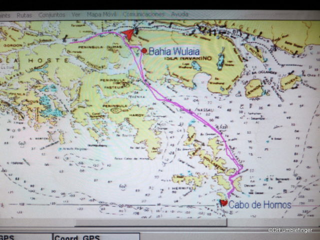
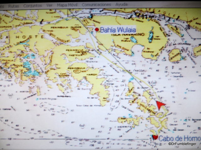
We headed south across Nassau Bay on the morning of our last full day aboard the Australis. Our hope was to be able to go ashore at Cape Horn (Cabo de Hornos), the most southerly island in the Tierra del Fuego archipelago — weather and conditions allowing. When I enquired about what our odds of going ashore were the night before, I was told 50-50. I think, in retrospect, that was an overly optimistic prediction.
Route Map, Cape Horn
It would have been nice to walk on this remote island, the most southern point of South America. It was discovered by the Dutch in 1616 and is known as the “End of the Earth”. Cape Horn has a sheer 425-meter (1,394-foot) high rocky promontory which overlooks …
.All Trips / Chile / South America
 Glacier Alley")
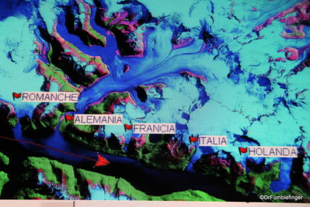
Situated along the Beagle Channel, Glacier Alley is a string of massive and picturesque glaciers that extend to the sea from the massive Darwin Ice Field (which covers 2500 km2) on Isla Grande, the largest island in Tierra del Fuego. These glaciers are named after several European countries — Holland, Italy, Germany, Spain and France (in Spanish — Holanda, Italia, Alemania, Espana and Francia). If it seems a little odd that …
Exploring the Fjords of Patagonia: 5) Glacier Alley
After an interesting morning exploring Pia Glacier and its surroundings, we returned to the Australis as she continued her journey. Our next attraction didn’t require leaving the Australis and could actually be enjoyed from the deck of our ship. We were to navigate through what’s commonly called “Glacier Alley”.
Map of our route through Glacier Alley
Situated along the Beagle Channel, Glacier Alley is a string of massive and picturesque glaciers that extend to the sea from the massive Darwin Ice Field (which covers 2500 km2) on Isla Grande, the largest island in Tierra del Fuego. These glaciers are named after several European countries — Holland, Italy, Germany, Spain and France (in Spanish — Holanda, Italia, Alemania, Espana and Francia). If it seems a little odd that …
Tagged Australis, Beagle Channel, Glacier Alley, Glaciers, Patagonia
.All Trips / Chile / South America
 Pia Glacier")
Exploring the Fjords of Patagonia: 4) Pia Glacier
Having finished a hike in Tierra del Fuego and studied birds up close on Tucker’s Islets, we completed a memorable day with an evening of fine food, good companionship and restful sleep. During the night our ship re-positioned itself and the next morning’s excursion was a visit to Pia Glacier.
Pia Glacier is in the north-west arm of the Beagle Channel and lies on the Darwin Range. It’s an advancing glacier, meaning …
Tagged fjordlands, glacier, Patagonia, Pia Glacier
.All Trips / Chile / South America
 Bird-watching at Tucker’s Islet")
Exploring the Fjords of Patagonia: 3) Bird-watching at Tucker’s Islet
After our morning hike in Tierra del Fuego we returned to the Australis for lunch and some rest, during which time our ship re-positioned itself in Ainsworth Bay. Our afternoon excursion was to be entirely on a Zodiac. This is obviously a slower process than zipping us onshore for the morning’s hike as the supply of Zodiacs was limited.
The Zodiacs took us to a small cluster of islands known as Tucker’s Islets. These lie within the Strait of Magellan and are rich in bird life (note: Magellan was the Portuguese explorer who visited this region 500 years ago). We would slowly circle these islands in the Zodiac to observe the different types of birds, slowing to a stop when possible, …
.All Trips / Argentina / South America
 The Australis")
Exploring the Fjords of Patagonia: 1) The Australis
There’s a fascinating leg of our Patagonian journey which I haven’t shared with you yet. We took a 4 day cruise into the Fjordlands at the southern end of South America, mostly coastal Chile and a bit of Argentina. This journey into Tierra del Fuego was a truly memorable adventure!
The cruise began at the Port in the frontier town of Puenta Arenas, Chile. Here we boarded the Chilean-owned adventure ship, Australis, which was to take us to the “uttermost end of the earth”. Australis is an expedition cruise company specializing in exploring the waterways of Tierra del Fuego, including the Strait of Magellan and Beagle Channel. The Australis is relatively small, carrying only about 200 passengers, which is very much to your advantage …
Tagged Argentina, Australis, Chile, fjordlands, Patagonia, Puenta Arenas, Tierra del Fuego
“Pic of the Week”, September 21, 2018: Views from Ushuaia

Ushuaia is the southernmost city in the world. It lies on the tip of Tierra del Fuego, off the Beagle Channel, and is surrounded by the Martial Mounts. This excellent location allows you to enjoy dramatic scenes of the sea, mountains and forests of southern Patagonia.
We spent a few days in Ushuaia after completing a memorable cruise through the Patagonian fjords. The weather was quite changeable and scenes of the city were often dramatic, especially when viewed from the hill where our hotel was located.
Ushuaia has a modern international airport and is the closest deep-water port to Antarctica. The last photos below are some of my favorites, with “Godbeams” of light penetrating the heavy cloud of a clearing storm.
(Click on …
Sep 20, 2018
Comments Off on “Pic of the Week”, September 21, 2018: Views from Ushuaia