 A Storm at Cape Horn")
We headed south across Nassau Bay on the morning of our last full day aboard the Australis. Our hope was to be able to go ashore at Cape Horn (Cabo de Hornos), the most southerly island in the Tierra del Fuego archipelago — weather and conditions allowing. When I enquired about what our odds of going ashore were the night before, I was told 50-50. I think, in retrospect, that was an overly optimistic prediction.
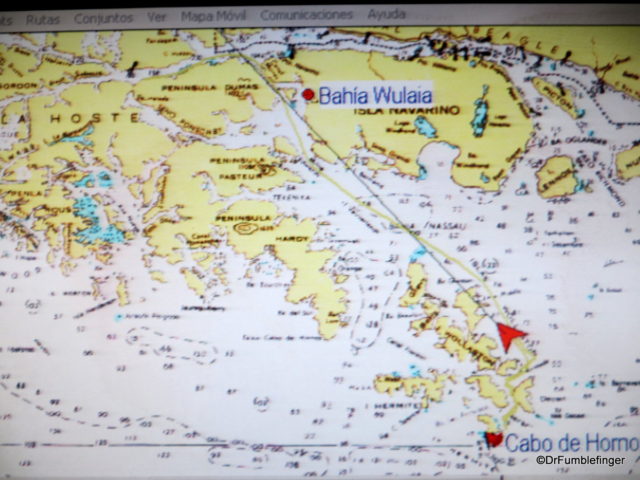
Route Map, Cape Horn
It would have been nice to walk on this remote island, the most southern point of South America. It was discovered by the Dutch in 1616 and is known as the “End of the Earth”. Cape Horn has a sheer 425-meter (1,394-foot) high rocky promontory which overlooks Drake’s Passage– the waterway between Antarctica and South America — long known to have the roughest water in the world. Cape Horn was an important historic navigation landmark, being half way between Australia and England.
The Chilean navy maintains a permanent lighthouse on the island (with a resident lighthouse keeper), as well as a small Chapel. A highlight of any visit is seeing the modern Cape Horn Monument (which forms the shape of an albatross) created as a memorial to all the sailors who have died around Cape Horn. The area — including marine regions, islands, channels, forests — is protected and was declared a World Biosphere Reserve by UNESCO in 2005.
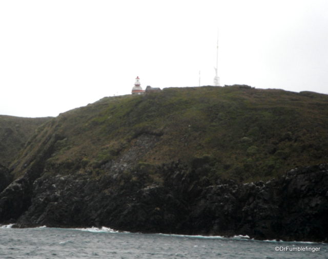
Cape Horn Lighthouse
As we approached Cape Horn, it was immediately apparent there was no way we would be able to attempt a landing. It was extremely windy, so windy that it was hard to walk on the top deck of the ship as you can see in the video clip below. It was even difficult to take these photos, given how the wind was shaking my camera.
Our crew attempted to put up a pirate flag, which they succeeded in doing with some difficulty. The wind was later to shred the flag.
The Australis attempted to show us views of Cape Horn, including the monument, before we headed north. The storm continued and grew stronger. Many of us aboard the Australis, including your humble narrator, grew progressively queasy. In fact, I’ve never been so sea sick in my life and spent a good part of the day lying in bed — but the bed and furniture in the cabin kept moving around as the ship was tossed and turned. Here is some early footage of the storm when it was “mild”. It got much worse.
Those few times I ventured out, I was lashed by the wind but got to see some monsterous waves. These were at times so massive they crashed over the fourth story window of our ship’s observation lounge. We were later told wind gusts at times had been clocked at 150 knots.
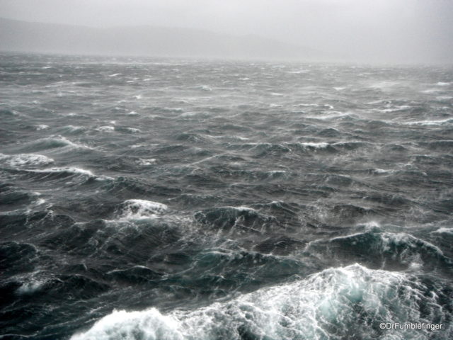
A storm at sea
Fortunately the rivets in the Australis held and this very rough water was to end that afternoon as we entered a wind-sheltered region. Fortunately my sea sickness disappeared quickly as the water calmed. We then departed for our last stop at Wulaia Bay before heading to port in Ushuaia. Stay tuned for that story next week.
(Click on thumbnails to enlarge, right arrow to advance slideshow)


