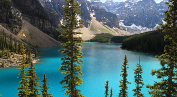
Moraine Lake is located a few miles south of Lake Louise in Banff National Park, in one of the most scenic and breath-taking locales of the Canadian Rockies. In the winter the lake is buried under a thick layer of snow and not accessible by car. The road leading to Moraine Lake is a popular cross-country skiing destination once enough snow has accumulated for the Park Service to groom it, but the skiing trail ends well before the lake because of high avalanche risk within its valley. During the summer months (June – Sept) Moraine Lake is popular and busy, even though it doesn’t thaw out until late June. Parking is limited so it’s best to arrive early. The lake has a lodge, which I’ve never stayed at. No camping is available at the lake.
Moraine lake is popular with canoeing and kayaking enthusiasts, and canoes are available for rent on the lake. But the area is primarily used by hikers to gain access to the backcountry of the Canadian Rockies. Grizzly bears are common in the area so during the summer it is mandatory to hike in tight groups of four or more (because no bear attacks on groups of this size have ever been documented).
Fortunately you don’t have to walk far or tire yourself to get some beautiful views. There are two easy hikes, one along the lakeshore and one which I absolutely love to share with visitors because it is easy and amazingly beautiful! The later hike is today’s topic, the Moraine Lake Rockpile Trail.

Moraine Lake viewed from it’s outlet
This great hike is to the pile of rocks deposited at the front edge of the last glacier to fill this valley (a.k.a. its frontal moraine), near where the lake drains into a creek. When you climb up it you are afforded beautiful views of the Valley of the Ten Peaks and the lovely turquoise water of Moraine Lake (the color imparted by silt produced by the hanging glaciers that surround the valley).
A short, interpretive trail leads up the Rockpile, located adjacent to the Lodge, the signage providing an introduction to the environment and the history of the Ten Peaks. From the lower parking lot, cross the bridge over the outlet stream and follow the trail to the top. There are many Picas and Marmots living in and around the rocks so you’ve a good chance of spotting these.
When I was younger the Canadian twenty dollar bill had a photo of the valley taken from the Rockpile. It’s obvious why this site has a special place in the heart of the Canadian people. There is no rush — sit on some rocks, enjoy a picnic lunch, and drink in the views.
When you are done, return to the trailhead. Be sure you take a look to east of the lake as you descend to enjoy the rest of the beautiful valley in which the lake rests. If there’s time, take a stroll along the lakeshore trail or even better, rent a canoe and paddle around the lake for a completely different perspective of it.
The drive to the lake is filled with wonderful scenery, including several hanging glaciers, so be sure to stop en route and enjoy the views!
Distance: 0.9 miles roundtrip, depending on where you started
Time: 20 minutes one way
Difficulty: Easy
Elevation gain: 30 m (100′)
Maximum elevation: 1919 m (6300′)
(Click on thumbnails to enlarge, right arrow to advance)