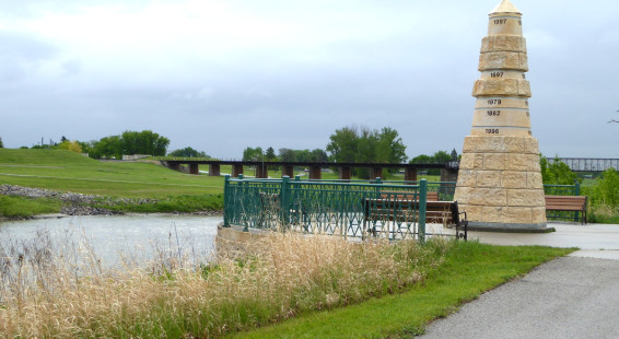
I’ve previously discussed how flat the great plains of central North America are. Like the Amazon basin in South America, when there is flooding of a river over its bank the flat topography lets the water spread a far distance before there is enough contour change to stop it. Obviously this can do a lot of damaged in populated areas.
The Red River, which flows through Minnesota and North Dakota on its way into Manitoba and on towards Lake Winnipeg, is one of the dominant rivers of the plains. It seems like the Red floods every few years and usually a small flood can be reasonably managed. But there are rare springs when the elements combine to make flooding particularly severe, such as a heavy snow pack melting quickly and heavy rains down-river.
To commemorate the varying high crest levels of the Red River’s flooding, Grand Forks created a memorial. This was largely to highlight the especially severe and devastating flood of 1997, the high water mark of which you’ll find at the top of the memorial. That particular year the flood did great damage to the communities around the river, especially Grand Forks. I thought the memorial did a great job turning an abstract idea into a very real indicator of how bad these floods can be. By my estimate, that’s probably almost 10 m higher than the summer level of the Red.
The Flood Memorial sits on the banks of the Red River in the Grand Forks Greenway, an extensive system of walking and bike paths heavily used in the summer. Near the Flood Memorial is the Sorlie Bridge, which connects the city of Grand Forks in North Dakota with East Grand Forks in Minnesota.
(Click on thumbnails to enlarge, right arrow to advance slideshow)