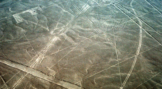
If you drive south of Lima on the Pan Am Highway in Peru, you’ll drive by (and through) the Nazca Desert along the foothills of the Andes. This is one of the driest places in the world. The average rainfall is less than an inch (<2 cm) a year and some years there’s no rain at all. The Nazca Lines are an amazing group of geoglyphs etched into the surface of the desert. There are about 300 hundred figures that comprise the Nazca lines including, besides lines, geometric shapes and pictures of animals and birds.
Along the highway you can stop at the Mirador tower, built along the Pan Am highway. This tower allows people to climb up and see a few of the Nazca lines for free. The view is limited, but there are definitely a few symbols and lines you can see from here.
The best way to experience the Nazca lines is from the air — in fact, it’s the only way most of these geoglyphs can be appreciated (apparently you can also see some from the tops of the hills around Nazca). We rented a ride in a small plane which flew us over the best of these lines, the photographic results of which you can see below. It was pretty rough flying, even though a short flight, and I’m glad I didn’t lose my breakfast.
Most everyone asks, “If you can’t see them except from the air, why were they made? And who made them?” The answer, in short, is that no one knows. The lines are very precise and were completed centuries before human flight. Some have speculated that they were signs left by an alien race? Landing strips for UFOs? A giant astronomical calendar (marking where celestial bodies rise at certain times of the year)? Others think humans created them for space aliens — to let astronauts (gods) know where to find them. It is probable that they served some unknown religious purpose, but only theories exist — no one knows why they were made or what they mean.
They are ancient, constructing sometime between 450 and 650 A.D. It’s amazing these lines have survived so long, but this is largely because of the lack of rainfall and relative windlessness of the region. The designs are shallow lines made by removing a few inches of the reddish pebbles at the surface and uncovering firmer whitish clay. The area encompassing the lines is nearly 500 km2 (190 sq mi), and the largest figures can span nearly 270 m (890 ft). The site was declared a UNESCO World Heritage Site in 1994.
Whatever their creator’s intentions, the lines are fascinating and worth a diversion to see. Here’s some of what you’ll see if you fly over the Nazca Lines.


