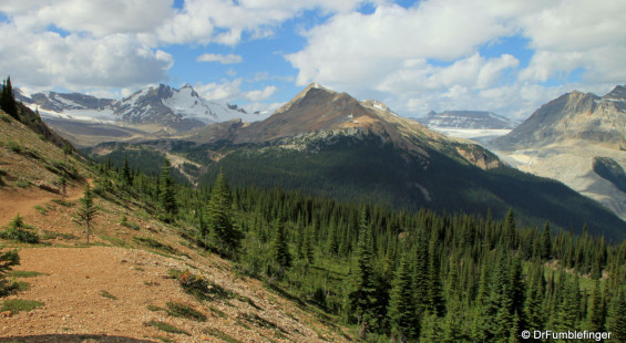
In a region of beautiful and dramatic scenery, Yoho Valley holds its own. The Yoho Valley Road is only a few kilometers east of the small town of Field, British Columbia, just off the very accessible TransCanada Highway. Don’t expect to be here alone — this a popular area, especially on nice summer days. Many who drive into the valley just stop to see Takakkaw waterfall, then continue on with their car trip. At 384 m high (with 254 m “free fall”), Takakkaw — pronounced Tah-kuh-kah, Cree for “it is wonderful” — is the tallest of a number of memorable waterfalls you’ll find when exploring Yoho Valley. It is one of Canada’s highest waterfalls.
I generally like to hike alone or with a small group of friends as I enjoy stopping for moments at a time to take in great scenic wonders or to photograph everything from flowers to glaciers! Because this is a rather remote region I decided to try hiking with Slow and Steady Hikers, a Meet-up group of like-minded individuals from Calgary whose leaders do a wonderful job organizing a large variety of hikes into the mountains each year. This turned out to be a smart move as I had the pleasure of sharing this day hike with a dozen friendly people all enthusiastic about being in Yoho National Park on what turned out to be a perfect summer day.
The Twin Falls/Whaleback hike is one of the more strenuous hikes I’ve done in the past few years. The loop is 22 km (14 miles) in length and has an elevation gain of almost 700 meters (over 2000 feet). But the trail is generally in good condition and there are plenty of rewards for your efforts. You pass five waterfalls (several of which are truly world-class), see more than a half dozen glaciers, several rivers, and sub-alpine meadows bursting with wildflowers. The scenery really varies a lot, from a walk in the forest to, once you’ve climbed towards the peak, a chance to stand near the precipice of a roaring waterfall while enjoy 180 degree panoramic views of the Yoho Valley.

Twin Falls Chalet
What follows is a chronology of the hike which you can skip over unless interested in the specifics. It would help those who want to use this information in planning a similar hike or to better understand the accompanying photos (for full screen enlargements, go to the slide-show playing below and click on the right sided icon — there’s some great photos in this bunch worth a detailed look!)
i) The hike begins adjoining Takakkaw waterfalls campground. A broad well-kept trail takes you upstream along the Yoho River. About 2 kms in there are short turnoffs to Angels Staircase Falls and Pont Lace Falls.
ii) Continue upriver towards Laughing Falls at 4.5 kms from the trailhead. The hike to this point is relatively flat, with minimal elevation gain.

Yoho Valley’s Twin Falls
iii) From Laughing Falls you begin a moderate ascent to Twin Falls situated at about 8 kms. As you walk uphill look for clearings towards the west (left) for your first views of Twin Falls, a memorable waterfall even at a distance.
iv) Twin Falls, as the name implies, is a paired waterfall that plummets over a 180 m limestone cliff. It’s a common destination for day hikers to stop before they head back to the trailhead. It’s certainly worth stopping here to look around. There’s the Twin Falls Chalet, a century old log cabin, a remnant of the Canadian Pacific travel days, where you can have tea or book a room (all must be reserved in advance). There’s a short looped side-trail that allows different views of Twin Falls and Twin Falls Creek which is well worth your time and offers a number of places to rest and scenic places to enjoy your lunch.

Precipice of Twin Falls, with view of Yoho Valley
v) As you leave Twin Falls towards the Whaleback (rounded rocky elevation point, nothing to do with the aquatic animal) you spend an hour doing the most strenuous part of the hike as you ascend to Waterfall Valley.
vi) From the plateau’s edge you can approach the northern fall of Twin Falls and stand near it as it plummets over the cliff, deafened by the thunderous roar of the water. Better still is to take in the grand panorama of the beautiful Yoho Valley. Photos simply don’t do it justice! Be sure you look to the northeast and see what you can of the Waputik Icefield.
vii) You cross a seasonally erected bridge over Twin Falls Creek to continue the remainder of the ascent to Whaleback. Not as hard as the initial part of the climb and with the added rewards of frequent wonderful views and a walk through a smallish sub-alpine meadow. When you reach the summit of Whaleback, you’ve walked 13 km and are at an altitude of 2210 meters.

View of Yoho Glacier from Whaleback Trail
viii) From the summit of Whaleback you begin a rather steep descent through a number of switchbacks into the Little Yoho River Valley to the south. Some great scenic views of “The President” and “Michael Peak”. (note: I would not recommend taking this trail in reverse and ascending towards Whaleback using this trail)
ix) Continue down the Little Yoho River Valley to Laughing Falls. Here you reconnect with the trail you walked earlier in the day as you make your way to the parking lot.
It’s best to start this hike very early and leave yourself lots of time to complete the loop. It was a little tiring but the views, especially near the highest altitudes of the hike, are memorable and so very worthwhile. It’s one of the best hikes I’ve completed, but I seem to say that about each hike in the Canadian Rockies. This place really is that spectacular!
(Click on thumbnails to enlarge, right arrow to advance slideshow)


